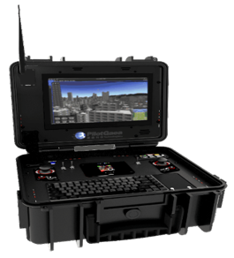
First domestic UAVs ground control system addresses current ground control systems' security and national defense concerns, provides a user-friendly developer kit for cross-system integration, and is compatible with most commercial UAV flight control systems. This system integrates advanced GIS technology to provide innovative features such as intelligent flight planning and visual landing assistance, offering users a superior control experience. It boasts advantages such as being built on a domestic map platform, supports multilingual, cross-platform development integration tools, and OTA automatic updates.
Established in 2001, PilotGaea Technology CO., LTD was founded to serve as a system integrator and project developer. We assisted clients in designing optimized systems across fields such as land administration, PDM, CAD Solutions and ThinClient platforms. In 2002, we solidified our technical foundations and assembled a research and development team. We found that there is great potential in GIS technology in the country, and decided that we would start to develop our own GIS software. Since then, we've become determined to become the best GIS software developer in Taiwan, creating professional GIS platforms that can compete on the international stage.
Name:James Chen
Phone:07-5548288 #136
Address:6F., No. 262, Wenxin Rd., Gushan Dist., Kaohsiung City 804615, Taiwan (R.O.C.)

MAS-E5G: Mixed-Reality and Artificial-Intelligent Manufacturing Assistant System Utilizing Enterprise 5G Networks
Is Ground Truth Always Correct? An Explainable Analytics Ecosystem: Understanding Misjudgments for Enhancing Decision-makings in Medicine and Recommender Systems
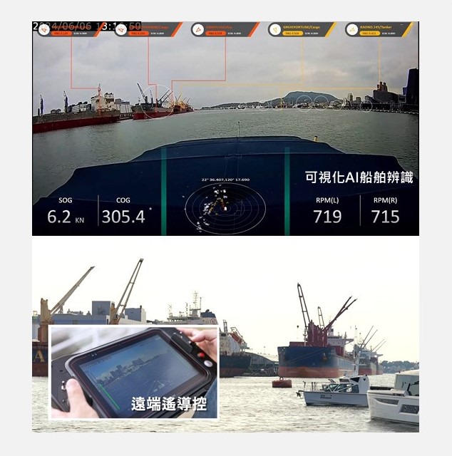
Artificial Intelligent Navigation Decision-Making Assistance System

Disaster Evacuation and Shelter Preparedness Assessment System
Technology maturity:Trial production
Exhibiting purpose:Product promotion
Trading preferences:Non-exclusive license
Coming soon!